GIS Mapping & Common Operating Picture Support
Geographic Information Systems (GIS) analysis and mapping of response assets, strategies, and data management within an Incident Command System framework during environmental emergencies and simulated exercises.
GIS Analysis & Common Operating Picture
NJR keeps you informed and ready to make important response decisions during a real or simulated emergency event. NJR’s Ready-Response Common Operating Picture is the latest GIS service available to clients to improve preparedness and allow for quick deployment. Please contact NJR’s GIS department for information on Ready-Response COP, assistance with exercise design, trajectory model construction, simulation field maps and data, and all emergency response mapping needs.
Spill Trajectory Modeling
NJR uses multiple modeling software packages, including RPS ASA OILMAP, to construct on-demand spill trajectory models during emergency responses or simulated exercises. Trajectory models provide valuable time-sensitive information about how a spill is moving and where it will threaten with respect to tides, currents, and weather.
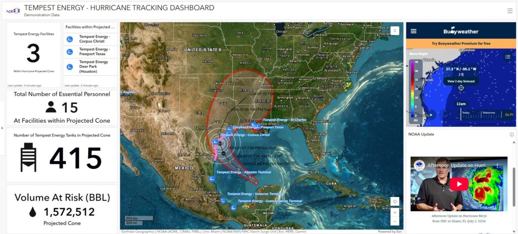
Natural Disaster Dashboard
Leveraging weather resources and GIS analysis tools, the dashboard provides a real-time view of potential threats overlaid on your operational data. This allows you to quickly identify assets, personnel, and infrastructure that may be in harm’s way. We built our prototype with hurricanes in mind, but the platform is adaptable for other natural disaster scenarios as well.

GIS & Mapping
- Overflight maps and reports
- Situation Status Maps detailing locations of response assets and strategies
- Oil spill trajectory maps and mass balance reports, graphs, and tables
- Wildlife observations and Shore Line Impact maps and reports
- Emergency Response and Pollution Control mapping for on/offshore facilities
- Track Natural Disaster Threats: Spatial relationships associated with your assets, operations, personnel, and response plans